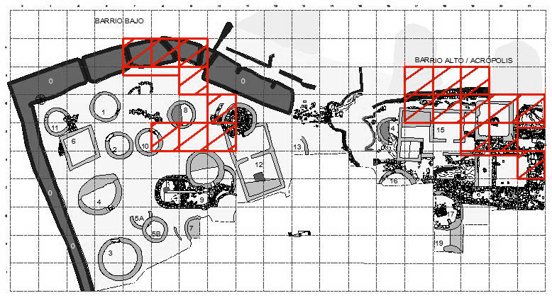
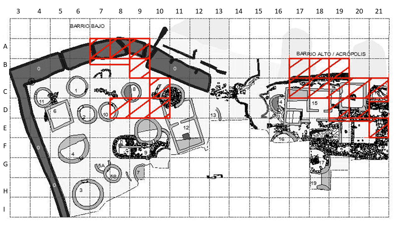
Durante esta campaña se excavó la zona al sur de la Estructura 9 donde se encontró un muro que en un primer momento se consideró un aterrazamiento que protegía la Estructura 9 y la parte baja del castro de derrumbes dado el marcado desnivel. En campañas posteriores se verá que este muro corresponde a la Estructura 12. Además se continuó la exhumación del barrio alto o acrópolis. También se continuó la excavación de la zona junto a la muralla situada al norte de la puerta del castro (Figura 4)
ESTRUCTURA 12 Y MURALLA
Continuando con la exhumación de las cuadrículas situadas al sureste de la Estructura 9, se encontró un muro situado en la cuadrículas D-10, que continúa por E-10, que en un primer momento fue considerado como protección de un aterrazamiento que evitase la gran pendiente de esta parte del castro y por consiguiente la posible destrucción de la parte inferior del poblado en esta zona. Esta pared impediría que se destruyera la Estructura 9 situada algo más abajo y en un nivel inferior al de la terraza sostenida por el muro, el cual se prolonga en F-11. Posteriormente, en campañas siguientes se haría evidente la pertenencia de este muro a la Estructura 12.
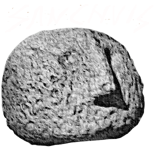
En D-10 se encontró adosado al muro una especie de machón o saliente, macizado con piedras, que permite pensar por su estructura inclinada que se trata de una rampa por la que descendía o subía de la terraza superior. Por la parte baja esta rampa se prolonga hasta la choza situada en C-10, de la que solo se excavó en esta campaña la pequeña parte enclavada dentro de la cuadrícula mencionada, que era sin lugar a dudas una choza castreña de planta circular, que el profesor Jordá Cerdá consideró que sin duda fue objeto de saqueo y destrucción en tiempos antiguos, ya que junto al muro y en el nivel superficial se
encontró una piedra con hoyuelo, tipo Coaña, en parte fragmentada y fuera de su posible emplazamiento, ya que se encontraba con el hoyuelo hacia abajo.
Esta habitación de C-10 y C-11 se encuentra junto a la muralla, de la que está separada por un estrecho paso con dos escalones, que ayudan a salvar el desnivel del aterrazamiento en esta parte.
También en la misma zona se excavó en la muralla, que fue expoliada por los vecinos hace algún tiempo de sus mejores bloques para construcciones caseras, por lo que se encuentra bastante destruida. No obstante pudimos observar sus cimientos en A-8, A-9, B-9, B-10 y B-11.
Salvo la piedra con hoyuelo, los hallazgos fueron muy escasos, ya que solo se recogieron unos pocos fragmentos de cerámica negruzca, de tipo tardío en la choza C-10 y varios fragmentos de sigillata, poco aprovechables, en la parte baja de la rampa que ya hemos señalado, así como restos de hierro, posibles clavos, muy mal conservados.
EL BARRIO ALTO O ACRÓPOLIS
Se trabajó sobre las cuadrículas D-19, D-20, C-17, C-18, C-19, C-20, C-21, B-17, B-18 y B-19. En C-19, C-20, D-19 y D-20 se registró la presencia de una habitación de planta rectangular (E-15/D) (Figura 1). Asimismo se continuó con la excavación de las cuadrículas E-19, E-20 y E-21, iniciada en la anterior campaña.
Dicha habitación tenía una puerta de acceso, orientada al este y se halla construida sobre un cimiento de bloques grandes escalonados, del tipo que se encuentra en Las Murías de Beloño (Gijón) (Jordá Cerdá, 1957).
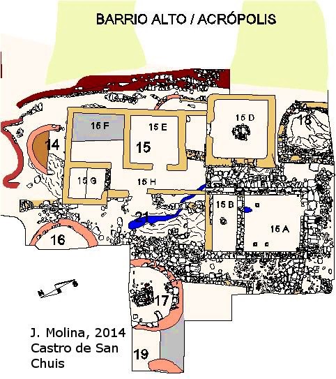 Figura 1. Distribución de las estructuras y nomenclatura actual del Barrio Alto | Distribution of the structures and current nomenclature of the Barrio Alto
En su interior se encontró un hogar y en la pared oeste una ventana, que fue tapada algún tiempo después. La puerta de entrada presentaba en su parte exterior una piedra de umbral mientras que para el interior se
observa un gran hueco con dos encajes en la parte baja de las lambas, lo que hace suponer que esta parte pudo estar construida en madera. En la pared de la ventana se observó la presencia de restos de enlucido o estucado, muy disgregados. En cualquier caso esta es una interpretación inicial (Figura 2) que posteriormente con la totalidad de la estructura exhumada cambiará. Se verá que hubo varias etapas tanto de construcción como de uso en las que la distribución de las diferentes habitaciones cambiaría.
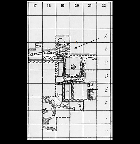 Figura 2. Plano de la época donde se observa la zona excavada en 1981 en la Acrópolis. Del archivo del profesor Jordá Cerdá | Plan from the period showing the area excavated in 1981 in the Acropolis. From the archive of Professor Jordá Cerdá.
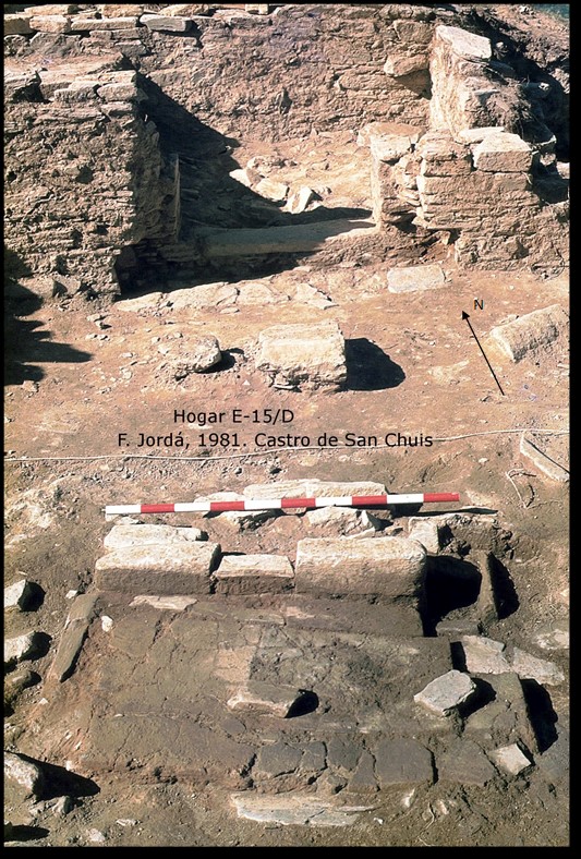
El hogar se encontraba aproximadamente en el centro de la habitación (Estructura 15 D en la Figura 1) y estaba formado por una solada de fragmentos de tégula, en uno de cuyos fragmentos podían observarse unos dibujos, y se limitaba por piedras de pizarra, que en el frente estaban a mayor altura que la solada, y en el ángulo de la izquierda de la entrada se encontraba lo que hemos denominado “brasero”, para guardar el rescoldo del fuego con objeto de su conservación (Figura 3).
Tanto la pared que linda con la muralla como la opuesta están totalmente destruidas como consecuencia de una zanja que abrieron hace años los buscadores de tesoros o recolectores de piedras. El cimiento de la pared oeste por el exterior se encuentra bajo el pasillo enlosado que existe entre esta habitación y las excavadas anteriormente. Debajo del enlosado se encontró un canal de desagüe (UE-21), que va en dirección norte y se encontraba cubierto por losas de pizarra. Este pasillo se continuaba en ángulo para poder dar acceso a la habitación recién excavada. Pero posteriormente en una segunda fase, el pasillo con el canal fue cortado uniendo con un muro las dos esquinas de las habitaciones, dejando dos zonas de ocupación independiente: una al norte formada por las estructura 15 E, F, G y H, y otra al sur formada con las estructuras A, B, C y D (Figura 1).
En el rincón formado por este nuevo muro divisorio y el muro de la habitación de la piedra con pocillo central se encontraron restos pertenecientes a varias vasijas, todas ellas fragmentadas y de pasta negruzca, de forma ovoidea, hecho raro en el Castro de San Chuis, en donde apenas se han encontrado restos de
cerámica abundantes y siempre tan fragmentados que resulta imposible reconstruirlos. En esta campaña se registraron 515 elementos.
During this campaign, the area at the south of the Structure 9 where a wall was found, was excavated. At first it was considered a terrain that protected Structure 9 and the lower part of the hillfort from landslides given the marked slope. In later campaigns it will be seen that this wall corresponds to Structure 12. In addition, the exhumation of the Upper Quarter or Acropolis continued. Also the excavation of the zone next to the rampart located to the north of the hillfort gate continued (Figure 4).
STRUCTURE 12 AND RAMPART
Continuing with the exhumation of the squares located at the Structure 9 southeast, a wall was found on the D-10 square that continues through E-10. At first, this wall was considered as a protection of a terrain in order to avoid the great pending of this hillfort part, and consequently, the possible destruction of the lower part of the village in this zone: wall would prevent the destruction of Structure 9 located somewhat lower and at a lower level than that of the terrace supported by the wall, which extends in F-11. Later, in subsequent campaigns, it would become evident that this wall was a part of Structure 12.
In D-10 square, a kind of buttress or protrusion, filled up with stones, was found attached to the wall, which due to its inclined structure could be considered an access ramp to the upper terrace. On the lower part this ramp extends to the hut located at C-10, from which only the small part located within the square mentioned was excavated in this campaign. This structure was undoubtedly a circular plant hut, which Professor Jordá Cerdá considered was looted and destroyed in ancient times, since next to the wall and at the surface level, a stone with central cuvette was found, Coaña type, partly fragmented and out of its possible location. This hut is next to the wall, of which it is separated by a narrow passage with two steps, which help to save the unevenness of the terrain in this part.
Also in the same area, the rampart was excavated. Its best blocks were subtracted by the neighbours some time ago for homemade constructions, reason why it is quite destroyed. Nevertheless, we could observe its foundations in A-8, A-9, B-9, B-10 and B-11.
Except for the stone with central cuvette, the findings were very scarce, as only a few fragments of blackish late type ceramics in hut C-10, and a few fragments of Terra Sigillata, not very useful, were collected in the lower part of the ramp, as well as iron remains, possible nails, very poorly preserved.
Everything excavated up at this moment with the exception of the wall, is part of what will later be discovered to be the Structure 12, a very interesting structure as we will see later.
THE UPPER QUARTER OR ACROPOLIS
In this hillfort area, the grids D-19, D-20, C-17, C-18, C-19, C-20, C-21, B-17, B-18 and B-19 were excavated. In C-19, C-20, D-19 and D-20 the existence of a rectangular plant room was registered (E-15/D) (Figure1). The excavation of the grids E-19, E-20 and E-21, that started in the previous campaign, was also continued.
This room had an access door, oriented to the east and is built on a foundation of large blocks stepped, of the same type that is found in Las Murías de Beloño site (Gijón) (Jordá Cerdá 1957).
Inside was a fireplace and on the west wall a window, which was covered some time later. The entrance door had a threshold stone on the outside while on the interior there was a large hollow with two fits where the door jamb was placed, which suggests that this part could be built in wood. In the window wall was observed the presence of remains of plaster or coated that were severely disaggregated. In any case, this is an initial interpretation (Figure 2) that will change later when the whole structure is exhumed. It will be seen that there were several stages of both construction and use, in which the distribution of the different rooms would change. We will study this later, although now we will give a small situation plan with the current nomenclature of the structures.
The fireplace (Structure 15 D in Figure 1) was approximately in the centre of the room and was made up of a tegula fragments patchwork, in one of which some drawings could be seen. It was bounded by slate stones, which in the front were higher than the floor. In the corner on the left, the fireplace presented what we have called ‘brazier’, a small area to keep the fire embers for its preservation (Figure 3).
Both the wall that borders the rampart and its opposite are totally destroyed as a result of a trench that the treasure seekers or stone collectors opened years ago.
The exterior part of the west wall foundation is under the paved corridor that exists between this room and those previously excavated. Underneath the pavement was found a sewage canal (SU-21) going to the north and covered by slate slabs. This corridor continued at an angle to allow access to the newly excavated room. But later, in a second phase, the corridor with the canal was cut, joining the two corners of the rooms with a wall, leaving two zones of independent occupation: one to the north formed by the structures E, F, G and H, and another to the south formed with structures A, B, C and D (Figure 1).
In the corner formed by this new dividing wall and the 15 D room remains belonging to several vessels were found, all of them fragmented and made of blackish paste, of an ovoid shape. This is unusual in San Chuis hillfort, where very few pottery remains have been found and always so fragmented that it is impossible to reconstruct them. In this campaign 515 items were recorded.
REFERENCIAS
REFERENCES
Jordá Cerdá, F. (1957). Las Murias de Beloño (Cenero, Gijón): una villa romana en Asturias. Memorias del Servicio de Investigaciones Arqueológicas, 2. Oviedo: Diputación Provincial de Oviedo, Servicio de Investigaciones Arqueológicas.
Molina Salido, J (2018). From the Archaeological Record to Virtual Reconstruction The Application of Information Technologies at an Iron Age Fortified Settlement (San Chuis Hillfort, Allande, Asturias, Spain), Oxford: Archaeopress Publishing Ltd.
Funciona gracias a WordPress
CASTRO DE SAN CHUIS © 2024 by JUANA MOLINA SALIDO is licensed under Creative Commons Attribution-NonCommercial-NoDerivatives 4.0 International
