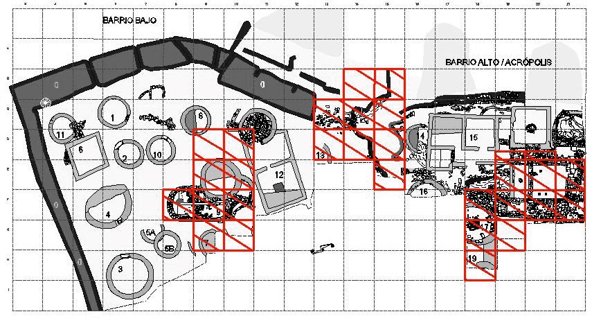
Durante esta campaña se trabajó sobre tres zonas distintas del castro: se continuó con la excavación de la Estructura 9, se completó la excavación de la puerta de acceso al castro descubierta en los 60 situada al este y se comenzó a excavar en lo que se conoce como el Barrio Alto o Acrópolis del castro.
ESTRUCTURA 9
Durante esta campaña se procedió a la exhumación de la zona A o parte oeste que había quedado sin excavar el verano anterior. Se comenzó por la cuadrícula A3, siguiendo la dirección S-N como en la campaña precedente. Aparecieron en primer lugar una importante cantidad de piedras pequeñas y, a medida que se
fue avanzando, fue descubriéndose un relleno que se prolongaba hasta lo que en la campaña anterior se consideró un posible enlosado. Este relleno estaba realizado incluso con argamasa y ocupaba los 2.06 primeros metros. A continuación volvió a aparecer el afloramiento de roca natural (al igual que en la otra mitad y a la misma altura), y a los 2.64 m desde el origen de la cata se encontró el arranque de lo que fue el muro de una habitación primitiva con un posible hogar adosado a él y a la roca natural (UE-73).
Siguiendo la línea sur norte, se llegó a la otra parte de los hogares superpuestos que ya habían aparecido el año anterior (UE-30 y UE-31) y se excavaron totalmente. Finalmente, y para comprobar el sistema de cimientos, se profundizó al lado del muro apreciándose un cimiento constituido por piedras menudas y argamasa sobre los cuales asentaban las piedras del muro.
También se procedió al dibujo de la serie estratigráfica descubierta en la Estructura (Figura 1):
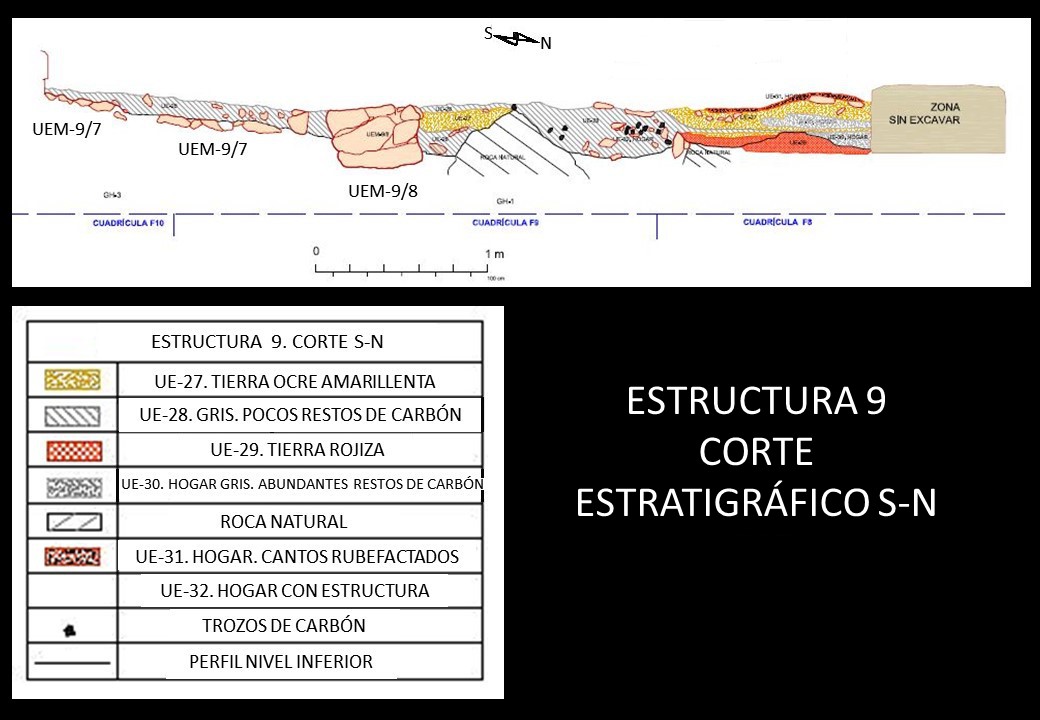 Figura 1. Serie estratigráfica del corte S-N de la Estructura 9. Del plano E-9/1 sobre lámina I-A del archivo de Francisco Jordá, dibujo original Antonio Guillén Oterino, delineado en CAD por Juana Molina Salido.
El corte interesa a las cuadrículas F8, F9 y F10. Desde el banco (F10) hasta la posible estructura del muro (UEM-9/8 en F8), nos encontramos con un nivel de tierra pisada de 3 cm, y un nivel inferior de color marrón grisáceo (UE-28) cuya potencia aumenta a medida que llegamos al posible muro; bajo este nivel aparece una especie de enlosado constituido por piedras irregulares y cuyo tamaño oscila entre 8 y 30 cm de longitud (UEM-9/7).
Entre el posible muro y la roca natural quedan 50 cm aproximadamente de estratigrafía con una potencia que llega a los 30 cm y que va disminuyendo progresivamente; aparecen en esta zona tres niveles: uno grisáceo de unos 4 cm (UE-28), otro ocre-amarillento de 10 cm en disminución (UE-27) y por último otro nuevamente de color grisáceo (UE-28).
Inmediatamente después de que aparece la roca natural nos encontramos con el corte de un hogar (UE-32) de 76 cm de largo y 31 cm de potencia en el que no se aprecian estratos; únicamente se puede distinguir una tierra grisácea (UE-28) que hacia la parte derecha del hogar presenta abundantes incrustaciones de carbón. De aquí al final quedan 1.33 m, con unos 32 cm de potencia; en los primeros 78 cm se distinguen cuatro o cinco niveles: primero una película fina rojiza bastante difuminada (UE-31), después le sigue una de color amarillo (UE-27) con 10 cm de potencia, a continuación aparece una capa constituida por tierra gris con restos de ceniza y carbón (UE-28) siendo una penetración en cuña del hogar anterior; sigue una nueva capa ocre amarillenta (UE-27) de 4 cm, para terminar en un suelo natural rojizo de descomposición (UE-29).
Quedan ahora 55 cm con tres o cuatro niveles no bien definidos: una capa muy fina constituida por tierra rojiza muy pisada (UE-31), otro nivel muy fino también muy pisado de color amarillento (UE-27), una zona constituida por piedras pequeñas y restos de carbón con 20 cm de potencia (UE-30) y, por último, el suelo rojizo de descomposición (UE-29).
Por lo que se refiere a los hogares, todos aparecieron en el área comprendida entre el afloramiento de roca y el ábside, y por tanto, dentro de lo que hubiera podido ser una antigua habitación.
Se distinguen tres tipos atendiendo a su constitución (Figura 2):
- Hogar con estructura. En la mitad correspondiente a la parte O de la habitación se halló un posible hogar (UE-73) adosado al antiguo muro y a la roca natural apareciendo a unos 20 cm de profundidad y a 70 cm del testigo central. No fue posible asegurar que fuese un hogar porque no se observó ningún cambio de coloración en el terreno. En la mitad correspondiente a la parte E, y también adosado a la roca natural, nos encontramos con un nuevo hogar (UE-32) que forma parte del testigo central y que apareció a 35 cm de profundidad y aproximadamente a 2.55 m del ábside. También a unos 2.55 m del ábside y a unos 50 cm del testigo apareció otro hogar (UE-33) a unos 14 cm de profundidad; las dimensiones son distintas a las del hogar anterior y su diámetro es de unos 37 cm.
- Hogar de color rojo. (UE-31) A unos 80 cm del ábside y formando parte del testigo central. Si bien se limpia esta campaña, se descubrió la anterior. Este hogar apareció con numerosas piedras rubefactadas.
- Hogar de color negro. (UE-30) A 13 cm bajo el anterior apareció un hogar negro con una potencia de unos 3 cm.
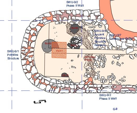 Figura 2. Detalle de la zona norte de la Estructura 9 en el que se pueden observar, entre otras cosas, la posición de los hogares | Detail of the northern area of Structure 9, where you can see, among other things, the position of the fireplaces. Del plano E-9/3 | Delineado por Juana Molina Salido
Además de esta zona de la casa, se excavó también la parte sur donde se hizo visible una escalera de piedra que ponía en comunicación las dos secciones de la estructura que se encontraban a distinto nivel. Se trata de una escalera de 5 peldaños que contornea el muro UEM-9/4, y que comunica con una pequeña habitación UEM-9/5, de forma triangular con muros curvos, ambas exhumadas también en esta campaña. Finalmente fue posible comprobar que la estructura 9 ocupaba un área que se extendía por las cuadrículas E-8, E-9, F-8, F-9 y F-10 (Figura 3).
La estructura 9 es un claro ejemplo de la tendencia propia de la Segunda Edad del Hierro a integrar varias cabañas para formar una sola unidad de ocupación, tema que ya hemos analizado en epígrafes anteriores. Así, las UEM-9/1 y 4 son las más antiguas o primitivas, de la Primera Edad del Hierro. Después en una segunda fase y durante la Segunda Edad del Hierro estas estructuras se integrarían en una sola por medio de las UEM-9/2 y 5, quedando salvado el desnivel entre ambas por la escalera.
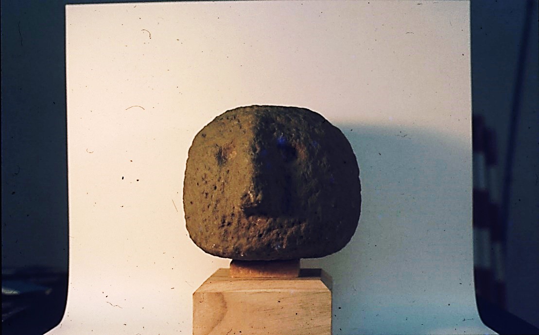
Precisamente en la cuadrícula F-10 se descubre otra estructura circular, ya separada de la habitación, si bien por un estrecho pasillo, la UEM-9/6. Es en este estrecho pasillo donde se encontró una escultura antropomorfa muy interesante, que el profesor Jordá Cerdá interpreta, tanto por estratigrafía como por el tipo y técnica, como una obra de época romana, aunque podría suponérsele reminiscencias de antiguos cultos. Se trata de una cabeza humana de forma redondeada, achatada por la base, en donde existe un agujero, que seguramente sirvió para su sujeción. Ofrece dos ojos excavados y una nariz prominente y curva; carece de boca, las cejas y el arranque del cabello se dibujaron con surcos trepanados (Figura 4).
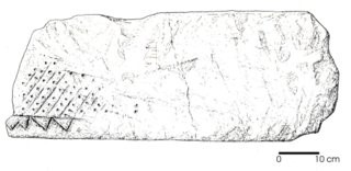
Por otra parte, junto al escalón de acceso a la vivienda apareció un umbral decorado (Figura 5).
LA PUERTA SURESTE
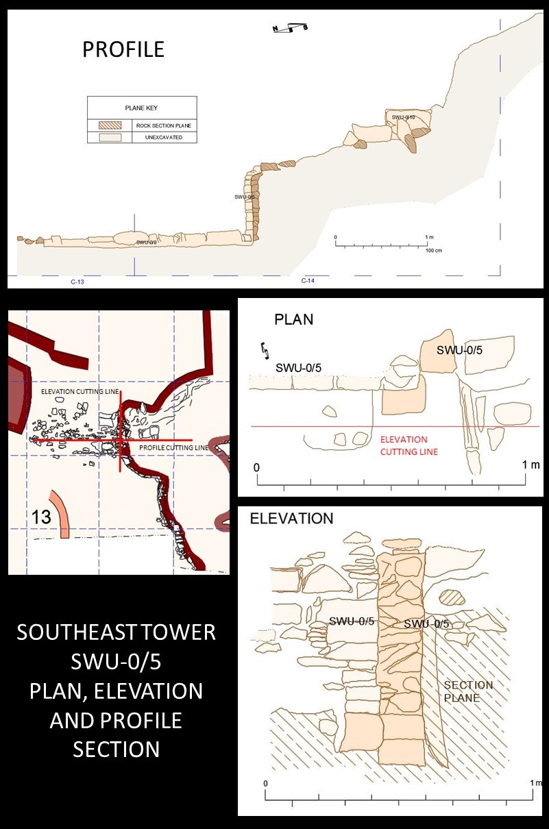
En la muralla este, conocida desde antiguos trabajos, se había localizado la abertura de una posible puerta. La excavación ocupó las cuadrículas C-13, C-14, C-15, D-14 y D-15. Se puso al descubierto un gran torreón, que al exterior enlazaba con la muralla y se quedaba en la entrada en ángulo recto, mientras que en el interior ofrecía una gran base curva, con varias zanjas o cimientos a distinta altura, debido a la inclinación del terreno. La estructura rectangular estaba separada de la curva por una especie de acceso, que conducía al interior
de la torre. Este acceso estaba bordeado en su parte exterior por una especie de canal que debía de servir para empotrar algún medio defensivo (detalle de planta y alzado en figura 82). Esta gran estructura defensiva debía de tener una gran altura a juzgar por los dos niveles, que estimamos de 8 a 10 m y serviría de puesto de vigía y defensa, ya que esta es la zona de más fácil acceso al castro (Figura 6)
LAS ESTRUCTURAS 15 Y 17
La Estructura 15 se sitúa en la parte más alta del castro (Barrio Alto o Acrópolis). Precisamente en esta área y en la cota más alta del cerro (789 m sobre el nivel del mar) se realizaron hace años varias zanjas por excavadores clandestinos, una de ellas en una zona en la que, según la tradición popular, habría existido una “iglesia”. Pues en esta misma zona se realizó en 1980 una amplia excavación que tuvo como resultado el descubrimiento de una estructura arquitectónica de plantas rectangulares denominada Estructura 15, si bien el
profesor Jordá Cerdá en un primer momento la denominó ER. El área excavada se extendió por las cuadrículas D-19, D-20, D-21, E-19, E-20, E-21, F-17, F-18, F-19, F-20, G-18 y H-18.
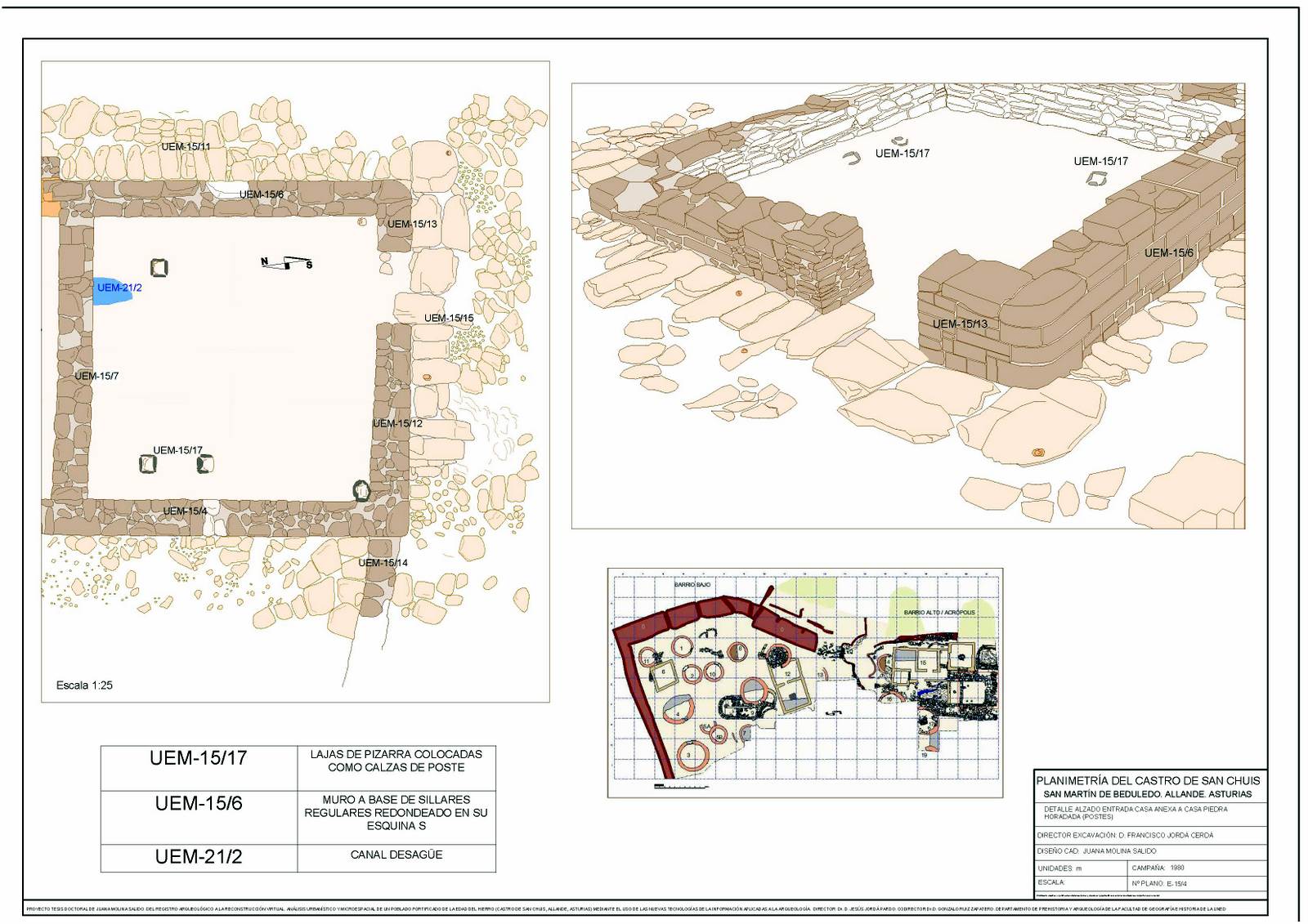
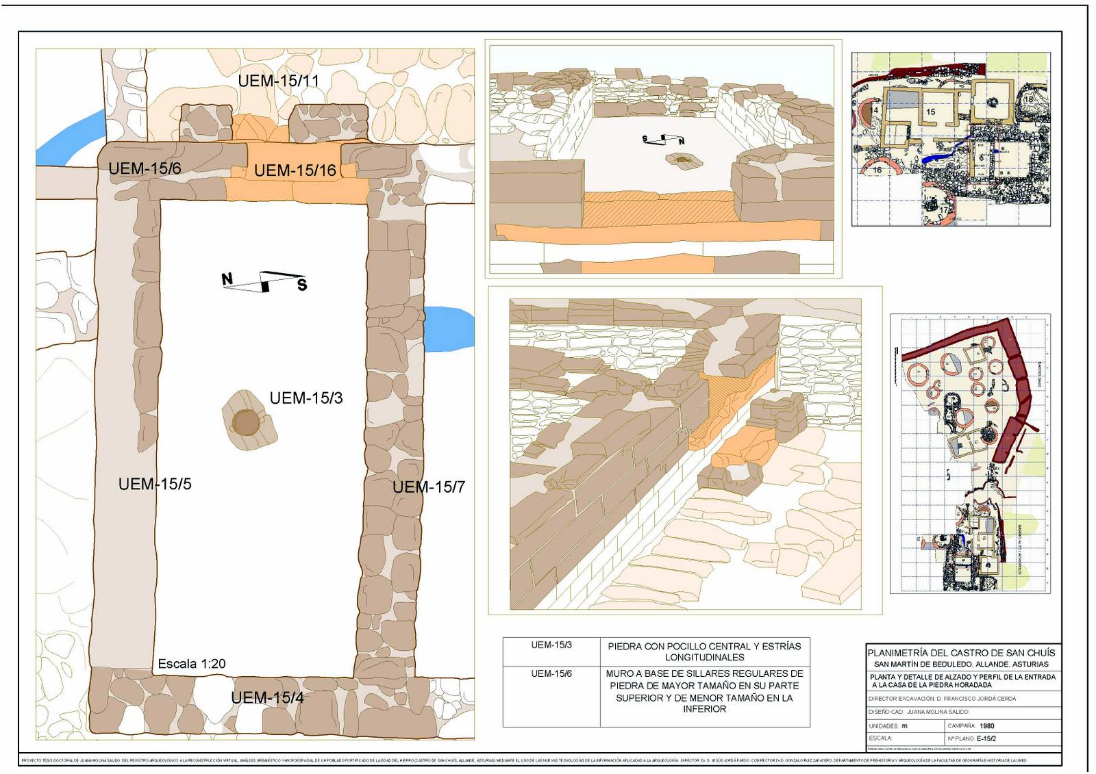
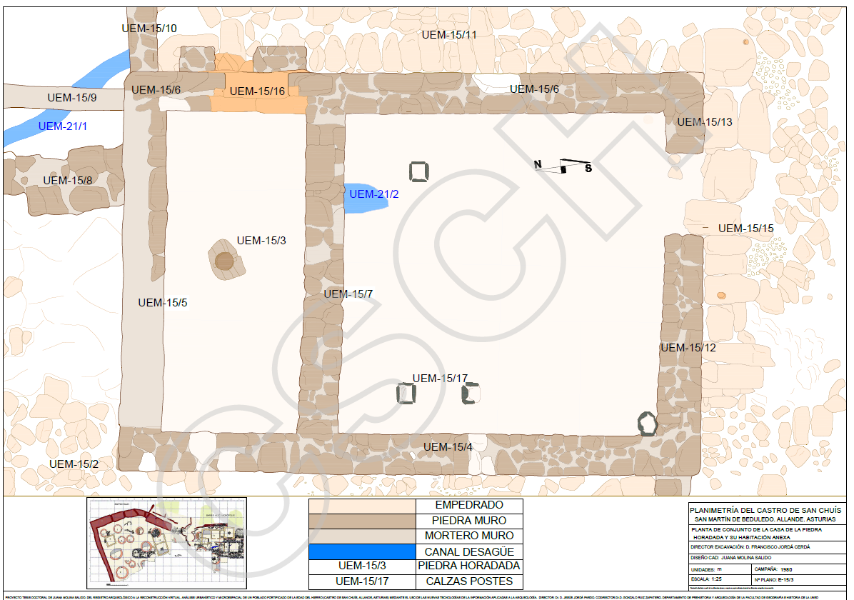
La parte de la Estructura 15 que se exhumó (Figura 7) estaba formada por dos habitaciones separadas entre sí por un muro medianero, sin comunicación entre ellas y a las que se accedía por distintas puertas.
La ER-1, es de planta rectangular alargada y tiene un frente de entrada con puerta descentrada hecho con un muro de grandes sillares alargados y tallados delicadamente con una esquina redondeada. En el centro de la habitación se encontró una gran piedra con un pocillo central, semejante a las piedras con pocillo de Coaña y otros yacimientos. En la parte del fondo y en el ángulo derecho según se entra existe un orificio al final de la pared N, que comunica al exterior.
En ER-2 nos encontramos con una puerta de acceso situada en el muro sur, también descentrada hacia el E. En su interior había un suelo de tierra apisonada y los restos de un posible hogar de forma rectangular situado sobre el muro W y determinado por dos pequeños hoyos rectangulares, en los que debió anclarse una estructura de madera, que debió de servir para la salida de humos. En esta habitación se encontraron unos pocos fragmentos de cerámica, sigillata y común, que indican su utilización por lo menos durante la segunda mitad del s. I d. C. En ER-1, los fragmentos de cerámica fueron raros y poco específicos aunque hacen suponer una fecha semejante a la de ER-2 (Figuras 8, 9 y 10).
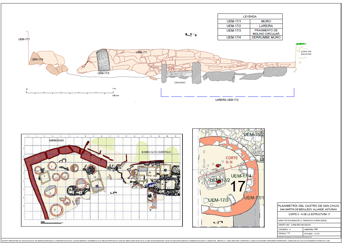
Junto al muro N de ER-2, nos encontramos con una especie de peldaños, formados por lajas de pizarra, lajas que cubren todo el espacio exterior de ER-2, tanto por la pared norte, como por la oeste, por la que discurre una especie de pasillo limitado por la pared oeste de ER y otro muro que pertenece a una estructura rectangular de la que solo conocemos este muro, al final del cual y en su extremo norte nos encontramos con una habitación circular (E-17) cuya entrada parece que se efectúa desde la segunda ER, y en la que se encontró un hogar rectangular, solado con pizarra y limitado por lajas de la misma piedra, que uno de sus ángulos ofrecía un pequeño recuadro cuya función desconocemos, aunque la suponemos ligada al arte culinario. En dicha habitación se encontraron dos piedras de molino, una de ellas rota (Figura 11).
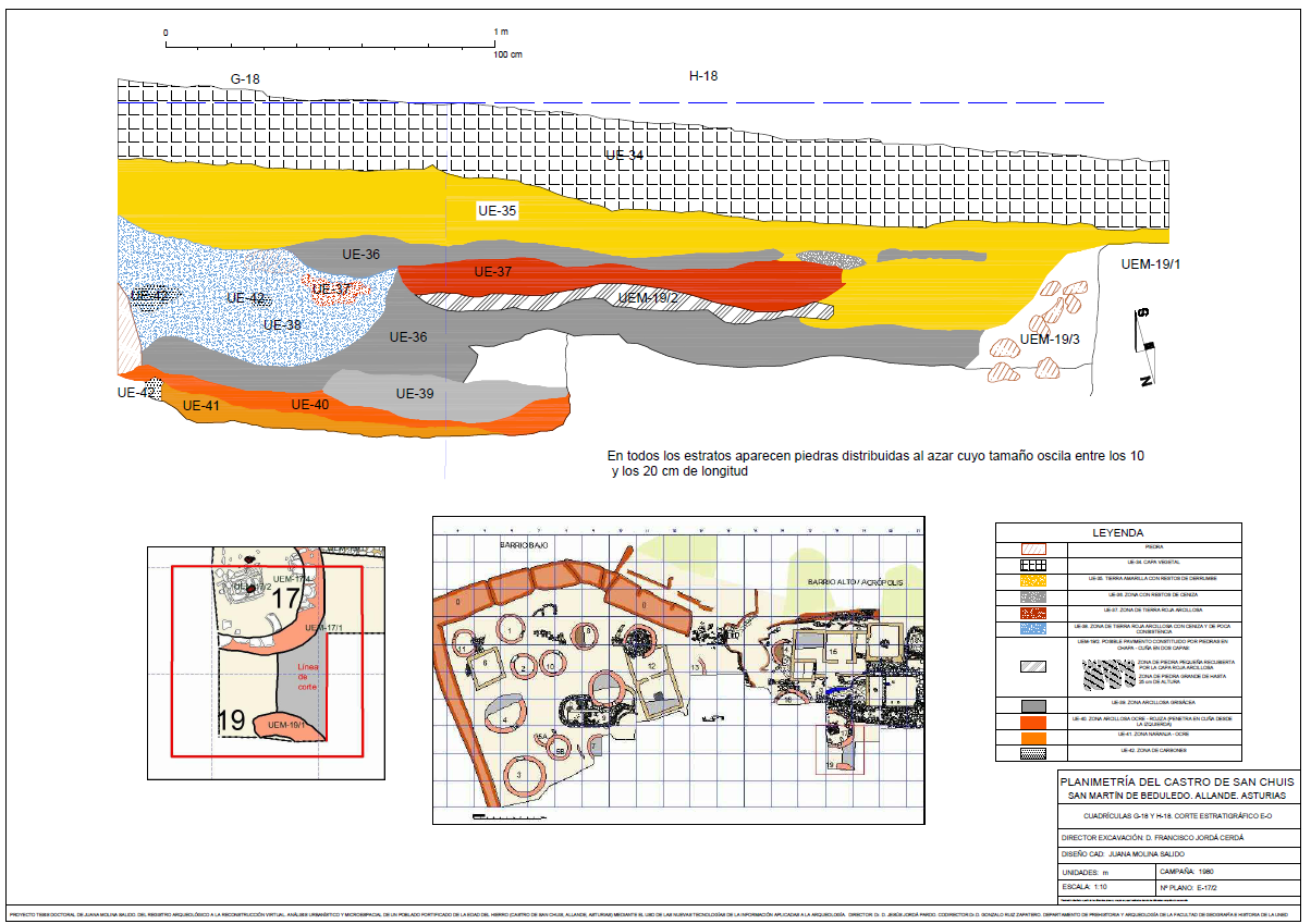
Todavía se exhumó otro muro de una habitación de planta circular cercana a la que acabamos de describir (E-19). La serie estratigráfica que proporcionó el corte este-oeste entre la E-17 y la E-19 queda como sigue:
− UE-34 (Nivel I), Como en todo el castro manto vegetal negro.
− UE-35 (Nivel II). Tierra amarilla con restos de derrumbe. Se repite en buena parte de las series estratigráficas que da el castro.
− UE-36. Capa de tierra con restos de ceniza. Igual que con la anterior es repetitiva. Prácticamente se divide en dos al incrustársele la UE-37 y la UEM-19/2, la primera de tierra roja arcillosa y la segunda el pavimento.
− UE-37. Tierra roja arcillosa. En la cuadrícula H-17 se incrusta dentro de la UE-38.
− UE-38. Capa de tierra roja arcillosa con ceniza y poca consistencia. En su interior aparecen restos de carbones (UE-42) y se le incrusta parte de UE-37.
− UE-39. Capa arcillosa grisácea
− UE-40. Capa arcillosa ocre rojiza que penetra en cuña desde la izquierda.
− UE-41. Capa de color naranja-ocre.
− UE-42. Embolsamientos de carbones que se insertan en la UE-38 y otra bolsa junto a UE-41 cubierta en este caso por UE-40.
Los restos encontrados fueron escasos, en total se registraron 543 elementos. La cerámica sigillata y común dieron fechas que van desde el siglo I al III d. C.
En el área ocupada por la estructura rectangular, tanto al interior como al exterior, se encontraron numerosos restos de clavos de distintos tamaños, aunque faltan los tipos instrumentales.
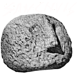
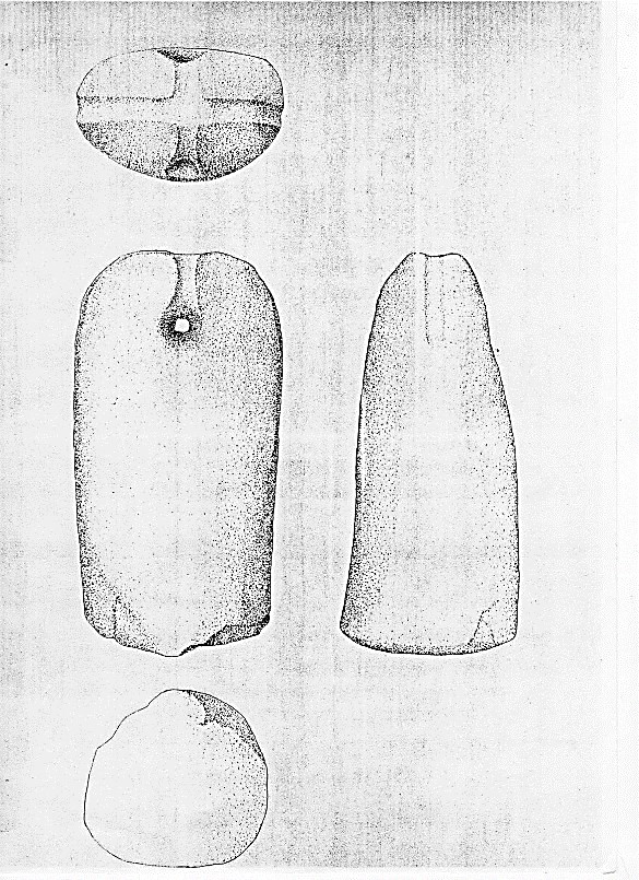
Bajo una de las pizarras que formaban los escalones que se encontraban junto al muro norte de ER-1 se encontró un pondus en perfecto estado. Se trata de una gran piedra de caliza compacta que tiene forma más o menos cilíndrica y que en su parte superior redondeada ofrece dos acanalados dispuestos en forma
de cruz, uno de los cuales une sus extremos con una perforación que atraviesa la parte superior de la pieza. Aunque en un principio se consideró la posibilidad de que fuese una piedra pilón, esta idea se descartó ya que su parte inferior no presentaba las señales típicas de la percusión. Por otra parte, se especuló con que se tratase de un ídolo dadas las condiciones en que se encontró junto al muro de ER-1 y debajo de un escalón.
Sin embargo análisis posteriores (Adán Álvarez 2000) han descartado esta posibilidad, señalándolo como un
pondus.
Throughout this campaign, works were performed on three different areas of the hillfort: the Structure 9 excavation was continued, the hillfort access gate discovered in the 60’s was excavated completely, and the excavation in which is known as the hillfort Upper Quarter or Acropolis began.
STRUCTURE 9
In this campaign zone A or western part of Structure 9 that had not been excavated the previous summer was exhumed. It began by the square A3, following the direction south-north as in the previous campaign. A large number of small stones appeared in the first place and, as the excavation progressed, a filling was discovered that continued until what was considered a possible pavement in the previous campaign. This filling was made even with mortar and occupied the first 2.06 meters. Then, the outcropping of natural rock (as in the other half and at the same height) reappeared, and at 2.64 m from the origin of the trench was found the start of what was the wall of a primitive room with a possible fireplace attached to it and to natural rock (SU-73).
Following the north-south axis, the other part of the overlapping fireplaces that had already appeared the previous year (SU-30 and SU-31) were reached and completely excavated. Finally, to verify the foundation system, the excavation beside the wall went deeper, appreciating a foundation constituted by small stones and mortar on which the stones of the wall were set.
The stratigraphic series discovered in the Structure 9 were also drawn (Figure 1).
The stratigraphic section encompasses squares F-8, F-9 and F-10. From the continuous bench (F-10) to the possible wall structure (SWU-9/8 in F8), we find a rammed earth level of 3 cm, and a lower greyish-brown level (SU-28), whose thickness increases as we reach the possible wall. Under this level appears a kind of pavement consisting of irregular stones whose size oscillates between 8 and 30 cm in length (SWU-9/7). Between the possible wall and the natural rock are approximately 50 cm of stratigraphy with a thickness that reaches 30 cm and that is progressively decreasing. In this area three levels appear: one greyish of about 4 cm (SU-28), another level ochre-yellowish of about 10 cm in diminution (SU-27) and finally another one again of greyish colour (SU-28).
Immediately after the natural rock appears, we find a fireplace (SU-32) of 76 cm long and 31 cm of thickness, in which no strata are appreciated. Only a greyish earth (SU-28) can be distinguished, which on the right side of the fireplace has abundant coal inlays. From here to the end are 1.33 m, with a thickness of about 32 cm. In the first 78 cm there are four or five levels: first, a rather diffused reddish thin film (SU-31) followed by a yellow layer (SU-27) of 10 cm of thickness. Below there is a layer consisting of grey earth with traces of ash and charcoal (SU-28) being a wedge-shaped penetration of the previous fireplace, this layer is followed by a new yellow ochre layer (SU-27) of 4 cm, to finish in a natural reddish decomposition soil (SU-29). In the remaining 55 cm, there are three or four levels poorly defined: a very thin layer consisting of heavily trodden red earth (SU-31), another very thin yellowish level also very stepped (SU-27), an area consisting of small stones and charcoal debris with 20 cm of thickness (SU-30) and, finally, the decomposition reddish soil (SU-29).
As far as fireplaces are concerned, they all appeared in the area between the rock outcropping and the apse, and therefore, within what might have been an old room.
Three types are distinguished according to their constitution (Figure 2):
1. Fireplace with structure. In the half corresponding to the west part of the room, there was a possible fireplace (SU-73) attached to the old wall and to the natural rock, which appeared a depth 20 cm and at 70 cm from the central baulk. It was not possible to assure that it was a fireplace because no colour change was observed on the ground. In the half corresponding to east part, and also attached to the natural rock, we find a new fireplace (SU-32) that constitutes part of the central baulk and that appeared a depth 35 cm and approximately at 2.55 m from the apse. Also about 2.55 m from the apse and about 50 cm from the baulk appeared another fireplace (SU-33) a depth of about 14 cm. The dimensions are different from those of the previous fireplace and its diameter is about 37 cm.
2. Red fireplace (SU-31). It appeared about 80 cm from the apse and taking part of the central baulk. Although it was cleaned on this campaign, it was discovered on the previous one. This fireplace appeared with numerous rubefacted stones.
3. Black fireplace (SU-30). At 13 cm below the previous one appeared a black home with a thickness of about 3 cm.
Figure 55
In addition to this area, the southern part of the house was also excavated. In this area, a stone staircase was made visible which put into communication the two sections of the structure that were at different levels. It is a 5-step staircase surrounding the SWU-9/4 wall that communicates with a small triangular room with curved walls (SWU-9/5), both exhumed also in this campaign. Finally, it was possible to verify that the Structure 9 occupied an area that extended through the squares E-8, E-9, F-8, F-9 and F-10 (Figure 3).
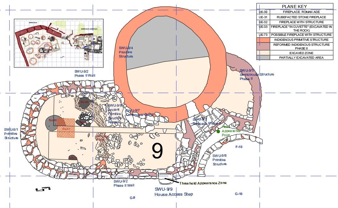 Figure 3. The entire Structure 9 excavated. You can see the staircase (SWU-9/3) that surrounds the SWU-9/4 and that arrives until the SWU-9/5. We can observe the oldest structures of the First Iron Age in salmon colour and those of the Second Iron Age in dark pink. In green the point where the sculpture of the head appeared. This point has been obtained by designing in CAD and georeferencing the original planimetry of the hillfort | Toda la Estructura 9 excavada. Se puede observar la escalera (UEM-9/3) que contornea la UEM-9/4 y que llega hasta la UEM-9/5. Podemos observar las estructuras más antiguas de la Primera Edad del Hierro en color salmón y las de la Segunda Edad del Hierro en rosa oscuro. En verde el punto donde apareció la escultura de la cabeza. Este punto se ha obtenido diseñando en CAD y georreferenciado la planimetría original del castro | Plan E-9/3 designed by Juana Molina Salido
Structure 9 is a clear example of the Second Iron Age trend to integrate several huts to form a single occupation unit. Thus, SWU-9/1 and 4 are the oldest or most primitive, of the First Iron Age. Then, in a second phase and during the Second Iron Age, these structures would be integrated in a single one by means of the SWU-9/2 and 5, being saved the unevenness between both by the stairs (Figure 3).
It is precisely in the F-10 square that another circular structure is discovered, separated from the rest of the Structure 9 by a narrow corridor, the SWU-9/6. It is in this corridor that a very interesting anthropomorphic sculpture was found, which Professor Jordá Cerdá interprets, both by stratigraphy and by type and technique, as a work of Roman times, although it could be reminiscent of old cults. It is a human head with a rounded shape, flattened by the base, where there is a hole, which surely served to hold it. It has two excavated eyes and a prominent curved nose; lacking the mouth, eyebrows and hair pulling were drawn with trephined grooves (Figure 4).
On the other hand, next to the house access step, a decorated threshold appeared
THE SOUTHEAST GATE
In the east part wall, known from ancient works, a possible gate opening had been located. The excavation occupied the squares C-13, C-14, C-15, D-14 and D-15. A great tower was exposed, which on the outside connected with the wall, forming in the entrance a right angle, while inside offered a large curved base, with several ditches or foundations at different height, due to the ground inclination. The rectangular structure was separated from the curve by a kind of access, which led into the interior of the tower. This access was bordered in its outer part by a kind of channel that had to serve to embed some defensive system (plan and elevation detail in figure 59). This great defensive structure should have a great height, we estimate from 8 to 10 m, judging by the two levels, and would serve as a lookout and defence tower, since this is the hillfort area with the easiest access (Figure 6).
STRUCTURES 15 AND 17
The Structure 15 is located in the hillfort highest part (Upper Quarter or Acropolis). Precisely in this area, and at the highest point of the hill (789 m above sea level), years ago several ditches were made by clandestine excavators, one of them in an area where, according to popular tradition, there would have been a ‘church’. In this same area was made in 1980 a large excavation that resulted in the discovery of an architectural structure of rectangular plan called Structure 15, although Professor Jordá Cerdá initially called it ER (Estructura Rectangular, Rectangular Structure). The excavated area was extended by squares D-19, D-21, E-19, E-20, E-21, F-17, F-18, F- 18 and H-18.
The Structure 15 part that was exhumed (Figure 7) was formed by two rooms separated from each other by a dividing wall, without communication between them and they were acceded by different doors. The ER-1 has an elongated rectangular plan and an entrance front with an off-centre door made of a wall of large elongated blocks and carved delicately with a rounded corner. In the centre of the room was a large stone with a kind of central cuvette carved, similar to that of Coaña hillfort and other sites. There is a hole at the end of the north wall, which communicates to the outside.
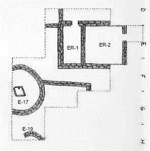 Figure 7. ER-1 and 2 and E-17 and E-19. From the archive of Professor Jordá Cerdá, drawing by Antonio Guillén Oterino,
In ER-2 we find an access door located on the south wall, also off-centre towards the E. Inside was a rammed earth floor and the remains of a possible rectangular fireplace located on the west wall and determined by two small rectangular holes, in which a wooden structure had to be anchored, which should have been used for the exit of fumes. In this room a few ceramic fragments were found, Terra Sigillata and common ceramic, indicating their use at least during the second half of the first century AD. In ER-1, the ceramic fragments were rare and unspecific, although they suggest a date similar to that of ER-2 (Figure 8).
Next to the ER-2 wall north, we find a kind of rungs, made up of slate slabs, slabs that cover all the outer space of ER-2, as much by the north wall as by the west. Through this last one runs a kind of corridor limited by the ER west wall and another wall belonging to a rectangular structure of which we only know this part. At the end of this wall and at its north end we find a circular room (E-17) whose entrance seems to have been made since the second ER, and in which a rectangular fireplace made with slate and limited by slabs of the same stone was found. One of its angles offered a small box whose function we do not know, although we suppose it linked to culinary art. In that room were found two millstones, one of them broken (Figure 11).
Another wall of a circular room near the one just described was still exhumed (E-19). The stratigraphic series that provided the east-west cut between E-17 and E-19 is as follows (Figure 12):
- SU-34 (Level I). As in all the hillfort, black topsoil.
- SU-35 (Level II). Yellow earth with traces of collapse. It is repeated in most of the stratigraphic series provides by the hillfort.
- SU-36. Earth layer with ash remains. As with the previous layer, it is repetitive. The SU-37 and the SWU-19/2, the first of red clayey soil and the second the pavement, are embedded in it dividing it in two.
- SU-37. Clayey red soil. In the H-17 square it is embedded within the UE-38.
- SU-38. Clayey red soil layer with ash that has little consistency. Inside it there are traces of coals (UE-42) and a part of SU-37 is incrusted.
- SU-39. Greyish clayey layer.
- SU-40. Reddish ochre clay layer, which penetrate in wedge shape from the left.
- SU-41. Orange-ochre layer.
- SU-42. Coal sack-up that are inserted in SU-38 and another bag next to SU-41 covered in this case by UE-40.
The remains of objects found were scarce, 543 items were recorded. The common ceramic and Terra Sigillata remains gave dates that go from century I to III AD.
In the area occupied by the rectangular structure, both inside and outside, numerous remains of nails of different sizes were found, although the instrumental types were missing. Under one of the slates that formed the steps that were next to the north wall of ER-1 a pondus in perfect condition was found. It is a large compact limestone that has a more or less cylindrical shape and in its rounded top offers two grooves arranged in a cross shape, one of which joins its end with a perforation that crosses the top of the piece. Although initially the possibility of a stone pylon was considered, this idea was discarded since its lower part did not show the typical signs of percussion. On the other hand, it was speculated that it was an idol given the conditions in which it was found, next to the ER-1 wall and under a step. However, later analyses (Adán Álvarez 2000) have ruled out this possibility, identifying it as a pondus.
REFERENCES
REFERENCIAS
Adán Álvarez, G. (2000). La industria lítica del castro de San Chuis (San Martín de Beduledo, Allande, Asturias). Investigaciones Arqueológicas en el castro de San Chuis (Allande, Asturias): Últimos Trabajos y Memoria
Final. Informe 2000. Inédito.
Molina Salido, J (2018). From the Archaeological Record to Virtual Reconstruction The Application of Information Technologies at an Iron Age Fortified Settlement (San Chuis Hillfort, Allande, Asturias, Spain), Oxford: Archaeopress Publishing Ltd.
