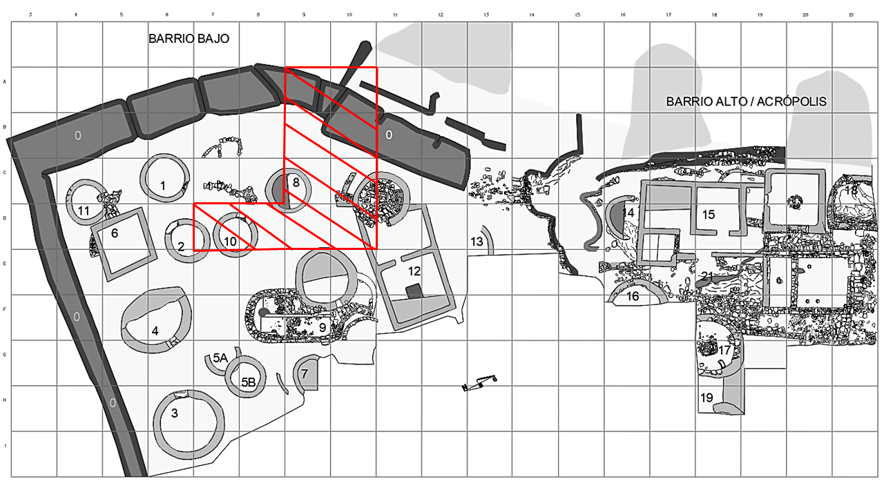
Durante la corta campaña de 1986 se realizó una limpieza general del área excavada hasta el momento y se eliminó toda la maleza crecida durante el año. Por otra parte durante la campaña arqueológica de 1985 se puso al descubierto una amplia área situada al norte de la Estructura 9. Esta zona, comprende las cuadrículas A-9, B-9, C-9, D-9, B-10, C-10, y D-10. Sin embargo las persistentes lluvias al final de la campaña no permitieron profundizar en toda su extensión, por lo que durante esta campaña se terminó su excavación. Además se consolidó la parte de la muralla conocida de la parte norte y se intentó comprobar y analizar el sistema defensivo a base de grandes fosos del castro.
EL BARRIO BAJO
Como ya hemos dicho se continuaron excavando las cuadrículas A-9, B-9, C-9, D-9, B-10, C-10, y D-10. En la primera capa superficial apenas se recogieron elementos arqueológicos aunque sí abundantes restos procedentes de arrastres de la parte superior del castro. Por debajo este nivel superficial se encontró un
nivel de destrucción, que cubría una serie de muros dispuestos de forma y modo complejos, que posiblemente formaban parte de una especie de contrafuertes angulares, que seguramente se construyeron con el objeto de salvar el desnivel existente entre la Estructura 9 y el suelo donde se hallan situadas las chozas de las cuadrículas más al norte.
Entre esta serie de muros y la Estructura 9, descubierta hace años, se encontró un relleno con materiales antiguos en el que se habían excavado sus muros, lo que venía a confirmar que la construcción de la habitación se produjo en varias etapas y fases, apoyándose parte de sus muros sobre los de una choza
circular en gran parte destruida.
En esta zona y nivel se encontraron y recogieron diversos materiales arqueológicos:
− Abundantes fragmentos de cerámica del tipo cuenco con restos de engobe rojo (distinto del propio de la imitación del Rojo Pompeyano) de variadas formas relacionadas con el menaje de cocina.
− Se recogió un lote de 31 fichas redondas talladas sobre fragmentos de Terra Sigillata que posiblemente formaban parte de algún juego.
− También se obtuvieron unos cuantos fragmentos de cerámica a la barbotina, del tipo parecido a los encontrados en la primera excavación realizada en el castro, que hacen suponer que el castro perduró
durante todo el s. I d. C.
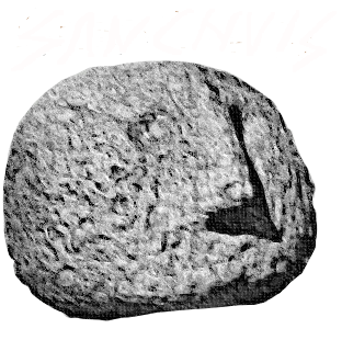
− Uno de dichos fragmentos de cerámica sigillata, de una posible forma Drag. 33, presenta un sello de alfarero en la base de la cara interna cuya posible lectura es EMILIRUM o quizás EMILIRUSTI/
− También se obtuvieron bastantes restos de hierro, bien propios de clavos, bien simplemente escorias.
− Una fíbula de bronce en omega.
Se procedió así mismo a la limpieza de cortes para refrescar la estratigrafía.
En las cuadrículas D-7 y D-8 apareció un pequeño enlosado en la parte de acceso a la choza.
LAS DEFENSAS
El perímetro amurallado del castro de San Chuis se conserva en buena parte relativamente bien aunque se observa la existencia de una posible destrucción en su ángulo noroeste. Entre esta zona y el ángulo suroeste del castro se abre una gran brecha aunque la zona está protegida por una amplia serie de cinco fosos de los cuales los tres más interiores son de grandes proporciones. Se procedió a la limpieza de estos con el objetivo de excavar un área específica de los mismos que proporcionase información sobre su construcción. El foso principal alcanza una profundidad máxima de unos 8 m, mientras que los otros dos apenas llegan a los 4 m.
El dispositivo de los cinco fosos ante la zona de más fácil acceso con sus posibles cinco vallados respectivos hacía suponer que estos fueron construidos con el objeto de colocar en ellos troncos inclinados que, a manera de piedras hincadas dificultasen el avance de los posibles atacantes. Sin embargo el mal tiempo obligó a suspender los trabajos no pudiendo comprobarse las hipótesis planteadas en lo que a las defensas se refiere. Posteriormente en la exploración con georradar de la zona se conocería la existencia de otras estructuras en esta área de las que hablaremos más adelante.
TRABAJOS DE CONSOLIDACIÓN
Se llevaron a cabo tanto en la parte de la muralla ya descubierta, como en algunas de las chozas, teniendo en cuenta principalmente aquellas que corrían peligro de destrucción.
Se reconstruyó en gran parte el paramento exterior de la muralla en las cuadrículas A-9 y A-10, cuyas piedras de gran tamaño habían sido arrancadas para construcciones de los pueblos vecinos. Esta recuperación se ejecutó de acuerdo con la técnica utilizada en su primitiva construcción. Además se cubrió
la parte superior con tierra donde se sembró gramilla para que su hierba sujetase la parte superior de la muralla.
Se intervino también sobre la Estructura 6, cuyas esquinas habían sido destrozadas por los curiosos. La Estructura 3 a su vez tuvo que ser limpiada de ruinas, consolidada en sus muros y nivelada. También se consolidaron los vanos en la Estructura 9 y la Estructura 12.
La muralla de la parte norte junto al ángulo noroeste tuvo que ser reforzada con tablas y troncos de madera que las apuntalasen con el objeto de evitar su posible caída y destrucción: esta parte del castro ha sido siempre la más perjudicada ya que por ella penetraban los agricultores con los carros y tractores para recoger los helechos y demás hierbas que utilizaban como cama para sus ganados. Con este apuntalamiento y reconstrucción se pretendía evitar la entrada de vehículos, lo que redundaría en beneficio de la conservación del castro.
During the short 1986 campaign a general cleaning of the area excavated until the moment was made and all the weed grown during the year was eliminated. On the other hand, during the archaeological campaign of 1985 an extensive area was exposed to the north of the Structure 9. This zone comprises grids A-9, B-9, C-9, D-9, B-10, C-10, and D-10. Nevertheless, the persistent rains at the end of the campaign did not allow to deepen in all its extension, reason why during this campaign its excavation was finished. In addition, the part of the known wall of the northern part was consolidated and an attempt was made to verify and to analyse the defensive system based on great moats of the hillfort.
THE LOW QUARTER
As we have already said, grids A-9, B-9, C-9, D-9, B-10, C-10, and D-10 continued to be excavated. In the first surface layer, barely archaeological elements were collected, although there were abundant dragging remains from the hillfort upper part. Below this surface level a destruction level was found, which covered a series of walls arranged in complex shape and form, possibly forming part of a kind of angular buttresses, which were probably constructed in order to bridge the slope between the Structure 9 and the ground where the huts of the northernmost squares are located.
Between these series of walls and Structure 9, discovered years ago, a filling with old materials in which their walls had been dug was found, which confirmed that the construction of the room took place in several stages and phases, leaning part of its walls on those of a largely destroyed circular hut.
In this area and level were found and collected various archaeological materials:
- Abundant fragments of bowl type ceramic with red engobe remains (different from the one of the imitation of Pompeian red ware) of varied forms related to kitchen equipment.
- A batch of 31 round token carved over Terra Sigillata fragments that were possibly part of some game.
- A few fragments of ceramic decorated with barbotine (slip-trailing) were also obtained, similar to those found in the first excavation carried out in the hillfort, which suggest that the hillfort lasted throughout the first century AD.
- One of the Sigillata ceramic fragments, of a possible Drag. 33 form, has a pottery workshop’s seal at the base of the inner face whose possible reading is EMILIRUM or perhaps EMILIRUSTI /
- Also, quite a few remains of iron, either of nails, or simply slag were obtained.
- A bronze omega-shaped fibula.
The cut lines of the stratigraphic sections were also cleaned in order to review it. On the grids D-7 and D-8 a small pavement appeared in the part of access to the Structure 10.
THE DEFENCES
The walled perimeter of the San Chuis hillfort is mostly preserved in relative good conditions although there is a possible destruction in its northwest corner. Between this zone and the hillfort southwest angle a great breach opens although the zone is protected by a wide series of five moats of which the three more interiors are of great proportions. They were cleaned with the aim of excavating a specific area of the same that could provide information about their construction. The main moat reaches a maximum depth of about 8 m, while the other two barely reach 4 m.
The five moats in front of the most accessible zone, together with their possible five fences, could mean that these were built with the purpose of placing in them inclined trunks that, as stone sunk, difficult the advance of the possible attackers. However bad weather forced to suspend the works preventing to verify the hypotheses raised as far as the defences are concerned. Afterwards in the geo-radar geophysical prospection the existence of other structures in the zone would be known of which we will speak later.
CONSOLIDATION WORKS
Works were carried out both in the part of the wall already discovered, as in some of the huts, taking into account mainly those that were in danger of destruction.
The outer facing of the wall was rebuilt largely on squares A-9 and A-10, whose large stones had been ripped off for constructions of neighbouring villages. This recovery was executed according to the technique used in its primitive construction. In addition, the top was covered with soil where couch-grass was planted in order to hold the top of the wall.
Work was also done on Structure 6, whose corners had been shattered by the curious. Structure 3 in turn had to be cleaned of ruins, consolidated in its walls and levelled. The openings in Structure 9 and Structure 12 were also consolidated.
The wall of the north part of the hillfort next to the northwest angle had to be reinforced with boards and wood trunks that propped them up with the object of avoiding its possible fall and destruction: this part has always been the most harmed since it was penetrated by the farmers with carts and tractors to collect the ferns and other herbs that used as a bed for their cattle. This shoring and reconstruction were made to prevent the entry of vehicles, which would benefit the hillfort conservation.
Funciona gracias a WordPress
CASTRO DE SAN CHUIS © 2024 by JUANA MOLINA SALIDO is licensed under Creative Commons Attribution-NonCommercial-NoDerivatives 4.0 International

